Tee Time: St. Charles real estate baron Greg Whittaker and the University of Missouri have struck a deal that could result in a pricey, golf-course subdivision next door to Weldon Spring, the region’s nuclear waste capital — and nobody sees that as a problem
Mizzou wants to sell land it owns in St. Charles County to a subdivision developer. Foes of the plan fear it will blight the scenic beauty of the KATY Trail. But neither side is mentioning the neighboring radioactive waste dump at Weldon Spring — or the possibility that other unknown environmental dangers may lurk nearby.
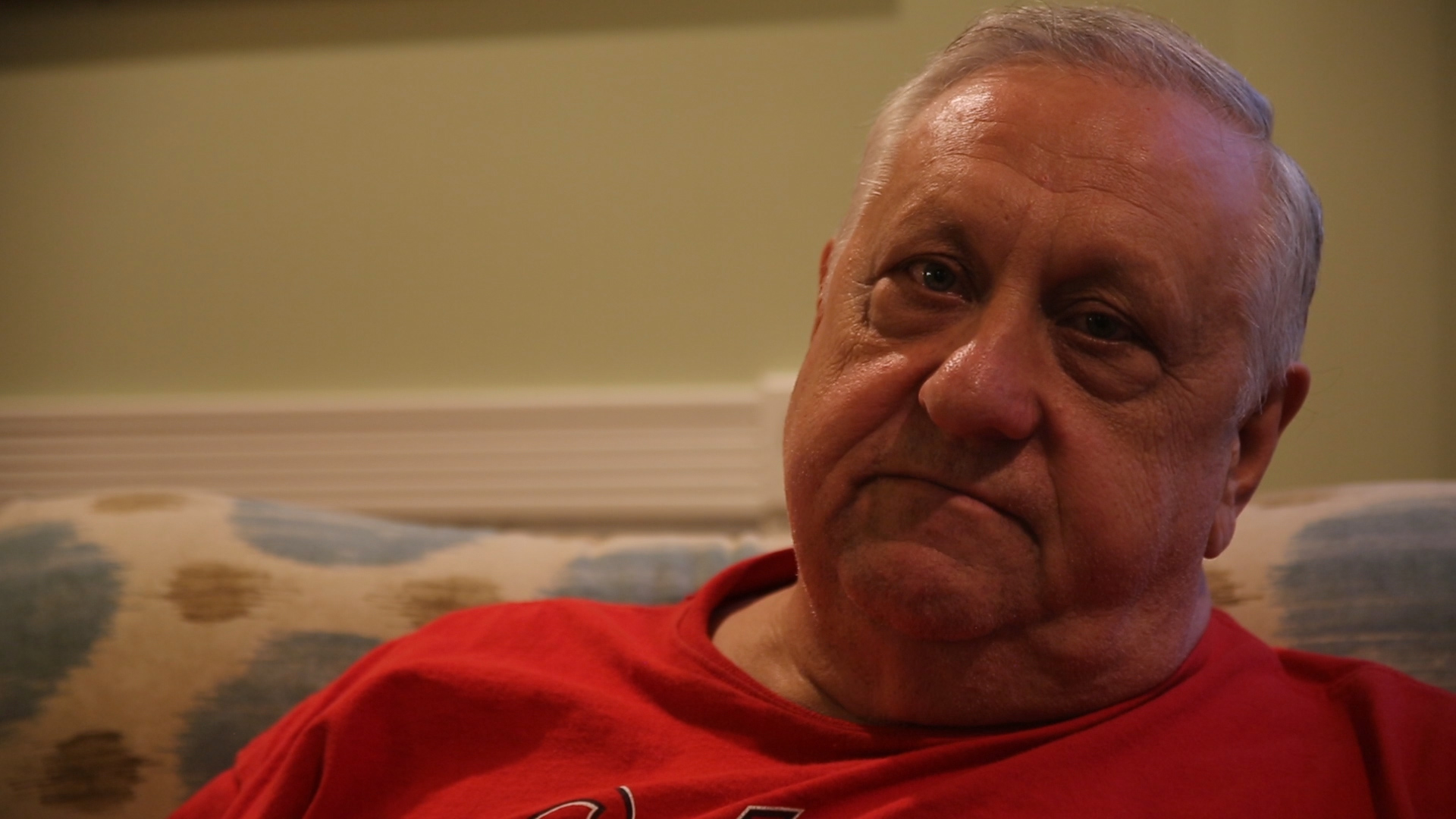
“There’s a lot of people who don’t even know Hamburg Quarry exists,” says Kenneth Kerpash, who once hauled rock from the limestone pit to barges moored on the Missouri River, where it was used by the U.S. Army Corps of Engineers to maintain the navigational channel.
Though the now-abandoned quarry in St. Charles County has largely escaped public attention since closing decades ago, Kerpash hasn’t forgotten the thousands of rusty barrels he says he observed there in 1972. At that time, he worked for the West Lake Quarry and Materials Co., which leased the quarry from the University of Missouri.
Mizzou sold the quarry and more than 7,000 acres of surrounding land to the Missouri Conservation Commission in 1978, and later built the Missouri Research Park on an adjacent tract. Facing budget problems, the school now wants to sell almost 200 acres of its remaining land at the location to a developer, who already leases a golf course on the property, and has plans to build hundreds of single-family homes and more than 70 multi-family units there.
NT Home Builders, owned by real estate mogul Greg Whittaker, is credited with building thousands of homes in St. Charles County. Its New Town development in particular has been lauded for its innovative design. A call requesting a comment from NT Home Builders was not returned by press time.
NT and the university have assured the public that the proposed development would adhere to the company’s high standards and won’t detract from the property’s scenic beauty or harm the environment. Opponents fear it will. Foes include existing residents and supporters of the popular KATY Trail State Park that borders the proposed high-end subdivision.
The contentious issue has spurred critics to send hundreds of emails to their elected officials in recent months, demanding the plan be scrapped. Adversaries have packed the gallery at St. Charles County Council meetings, and also posted informational notices along the KATY Trail.
Their hopes were buoyed in April, when the county’s Planning and Zoning Commission voted against permitting a zoning change that would allow the project to move forward. Nevertheless, on May 21, the council voted unanimously to delay its final decision to allow the developer more time to amend its already scaled back proposal.
The council’s deference to the developer dovetails with the university’s preferential treatment, which includes offering to sell the public land without a formal bidding process and failing to disclose the price tag. Lack of transparency has led to rumors of political corruption, and stirred recriminations and acrimony from all quarters.
None of the conflicting interests, however, seems to see the most obvious problem with the pending sale: If built, the proposed development would be within walking distance of the former Mallinckrodt uranium processing plant site in Weldon Spring — where the Department of Energy maintains a mountain of radioactive waste.

Retired Teamster Kenneth Kerpash says he saw thousands of rusty, leaking barrels stored at the Hamburg Quarry in 1972.
The idea of building new homes near a site known to have been contaminated with radioactivity in the past is unconscionable to 65-year-old Kerpash, a retired Teamster truck driver from Troy, Mo. In his opinion, the university and the developer are consorting for short-term gain at the expense of the health of future residents. Kerpash believes the parties to the deal are influenced by profit and the bottom line. “Money talks and bullshit walks,” he says.

Council Joe Cronin (1st Dist) urges caution.
St. Charles County Councilman Joe Cronin (1st Dist.) is less strident in his assessment. He says the federal government has told the council that the clean up of the Weldon Spring site has made the area safe. The feds also provide periodic updates, he says. But Cronin adds that serious health concerns are now being raised by some former students of the nearby Francis Howell High School. For this reason, the councilman urges caution.
“I will not vote on approving the proposed subdivision until we have all the facts, which we do not have as of yet,” says Cronin. “The university has owned the land of the proposed development for over 70 years. Waiting a bit more to determine the safety of the area would not be that much inconvenience to them.”
Under DOE guidelines, large swaths of the adjacent Weldon Spring Conservation Area have been deemed suitable for recreation, but unsuited for full-time human habitation because of the dangers posed by chronic exposure to radioactive contamination. Uranium and thorium present at the location are known human carcinogens and also have been linked to other chronic illnesses.
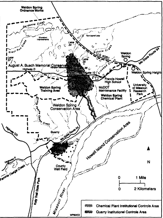
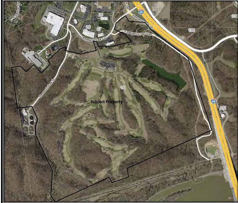
This DOE map shows the proximity of the radioactively contaminated Southeast Drainage system to the proposed residential subdivision. The University of Missouri is poised to sell the land for an unspecified amount.
In 2005, the DOE published its land use restrictions for the Southeast Drainage area — a 200-foot-wide, 37-acre tract that traverses the land between the proposed residential development and the abandoned Hamburg Quarry. At that time, DOE ruled that long-term institutional controls be imposed due to unsafe levels of radiation that still persist even after the completion of the clean up of that area. The affected tract is now owned by the Missouri Conservation Commission.
According to the DOE: “… [R]esidual soil and sediment contamination remains at some locations within the drainage at levels exceeding those that would support unlimited use and unrestricted exposure. Therefore, land use restrictions are needed in the drainage to prevent residential use or other uses inconsistent with recreational use.”
The advisory was published in a document entitled Explanation of Significant Differences, Weldon Spring Site in February 2005 by the U.S. Department of Energy’s Office of Legacy Management.
The message is clear: People are not supposed live within the designated boundaries of the 37-acre Southeast Drainage area. Under the DOE’s edict, this advisory applies in perpetuity. But apparently the University of Missouri feels that selling its nearby property does not violate its legal or ethical obligations to either the buyer or the public.

University of Missouri President Mun Y. Choi
“The purchaser has been given an opportunity to conduct any environmental studies they deem are necessary,” says a spokesperson for University President Mun Y. Choi. The spokesperson adds that the radioactive waste issue is common knowledge to the public.
“…Soil and sediment contamination remains at some locations within the drainage at levels exceeding those that would support unlimited use and unrestricted exposure.” — DOE
The property Mizzou wants to sell is part of the original tract of land that the federal government seized at the advent of World War II, and it shares the same sordid environmental history.
In their official records of decision, the DOE and EPA have advised that the primary means of enforcing its restrictions is through “institutional controls,” specifically local zoning ordinances. The St. Charles County Planning and Zoning Commission has already recommended not granting the developer a variance. Though the university’s property may fall outside the perimeter of the DOE’s restricted use area, honoring the spirit of the federal guideline would seem warranted to assure public health. But only one councilman clearly stated his opposition to the plan at the recent county council meeting.
At the May 21 council meeting, Councilman Mike Elam (Dist. 3) praised the developer and the merits of its plan but, nevertheless, rejected the proposal for one reason: its location.

Councilman Mike Elam: “I’m a no vote.”
“I really hate where they want to build this,” Elam told the audience. “The idea is really good. We wish that when people come to the county and they want to build something, they would be as accommodating as this developer has been,” Elam said. “I give them all praise for that. [But] I don’t care if you want to put in 450 homes or 250 homes or 50 homes — I still don’t like where the development is going in. I’m a no vote.” In his statement, Elam didn’t state why he was uncomfortable with the location.
The location also bothers Kerpash. From the retired trucker’s perspective, it’s inane to build new housing next to a site known to have been contaminated with radioactive waste. “It don’t take a real smart person to figure that out,” he says. “They just got done cleaning up the most hazardous place in Missouri,” he says, referring to the Weldon Spring site. “Now they want to build a subdivision there? It’s unbelievable.”
Kerpash admits he doesn’t know what was contained in the rusty barrels he observed at the Hamburg Quarry back in 1972. But when his recollection is added to other evidence, it is enough to give pause.
One red flag that he points out is that his former employer — the West Lake Quarry and Materials Co. — also operated and owned the West Lake Landfill in Bridgeton, Mo., where radioactive waste from the Manhattan Project was dumped illegally in 1973. In early March, the EPA belatedly announced its proposed clean up plans for the West Lake site, and the final remedy is pending.
Both sites are in the Missouri River watershed, which makes the lay of the land a factor to consider as well.

The DOE’s nuclear waste disposal cell on Route 94 — the site of the former uranium processing plant — sits on high ground, 1.5 miles uphill from Hamburg Quarry. On the official map of the Weldon Spring Conservation Area, the quarry is anonymously designated as a “restricted area,” directly next to the KATY Trail. In the 1990s, the DOE spent millions of dollars cleaning up radioactive contamination in the Southeast Drainage area in between the Hamburg Quarry and the proposed residential development. But unsafe pockets of radioactive contamination remain, according to the DOE.
Vestiges of the area’s dark history pop up at other nearby location, too. As part of its 16-year clean up, the DOE also remediated the nearby Weldon Spring Quarry, which is a short bicycle ride in the opposite direction via the KATY. There’s also a pipeline that carried treated radioactive waste water from the uranium processing plant clean-up site that skirts the Hamburg Quarry on its way to the Missouri River. The DOE has deemed all these locations suitable for recreation but not full-time human occupancy. Nobody is ever supposed to live here again.

No Man’s Land: Dwelling near this part of the KATY Trail is prohibited by the U.S. Department of Energy.
Surrounded by forested public lands and the river, the now-abandoned Hamburg Quarry appears isolated. Additional conservation land on both sides of the river add to the wilderness atmosphere. The location, however, is only a short walk from Mizzou’s Research Park, which links with the KATY by way of the Busch Greenway. On weekends, the path is crowded with groups of joggers, who run by the Missouri Bluffs Golf Club, the site of the proposed residential development.
Mallinckrodt operated its uranium plant between 1957 and 1966 under contract with the DOE’s predecessor, the Atomic Energy Commission. During this period, the plant and its grounds became polluted with radioactive waste. The contaminated materials were stored on site and also dumped at the Weldon Spring Quarry, four miles south of the plant. Between 1988 and 2002, the DOE oversaw an extensive clean up of both sites that cost almost $1 billion.

Bluffs tower over the Missouri River and the KATY Trail.
The verdant hills and limestone bluffs that border the Missouri River create an illusion that this area is pristine. But long before the uranium waste despoiled the land, it was poisoned by other byproducts of war.
With World War II on the horizon, the town of Hamburg, Mo. and two other villages were razed by the U.S. Army in 1940 to make way for the Weldon Spring Ordinance Works. During the war, the Atlas Powder Co. produced explosives at the site for the Army. Toxic waste from the TNT and DNT production polluted the area.
Mizzou acquired the tainted property after World War II from the federal government for $1. A current Google satellite image of the area shows the unmarked Hamburg Quarry as a spot of blue surrounded by green.
Kerpash suspects that the barrels he saw there in 1972 may still be at the bottom of the quarry lake. If the barrels contained chemical or radioactive materials, the porous limestone topography would allow the toxins to migrate into the groundwater and flow into the Missouri River.

The abandoned Hamburg Quarry is within a stone’s throw of the KATY Trail.
Nowadays, cyclists on the KATY Trail whiz by the old Hamburg Quarry without noticing it. The University of Missouri never rebuilt the town that bore the same name after it acquired the property from the Army after the war. Given the toxic history of this place, that was a good call.
Based on what he knows, Kerpash doesn’t think people should move back anytime soon.

On the Missouri Conservation Commission’s map, the old Hamburg Quarry is identified only as a “restricted area.”
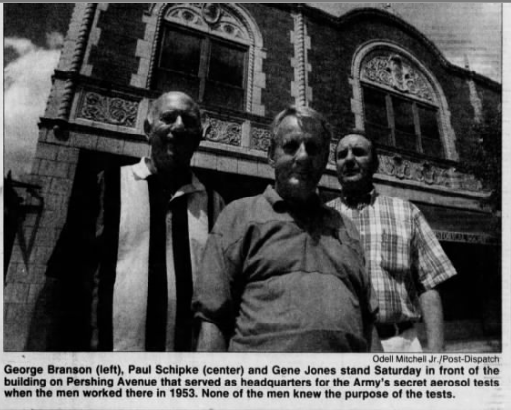 Post-Dispatch science reporter William Allen reported in July 1994, that the former Parsons employees in St. Louis were questioning whether their exposure to zinc cadmium sulfate during the testing was the cause of their cancer.


 In this case, the EPA gave its stamp of approval to allow children to play baseball in an area that was determined by its own testing to be radioactively contaminated.