A 1981 report prepared for the Nuclear Regulatory Agency raises more questions about the origins of the radioactive waste at the controversial West Lake Landfill Superfund site, including who dumped it and when.
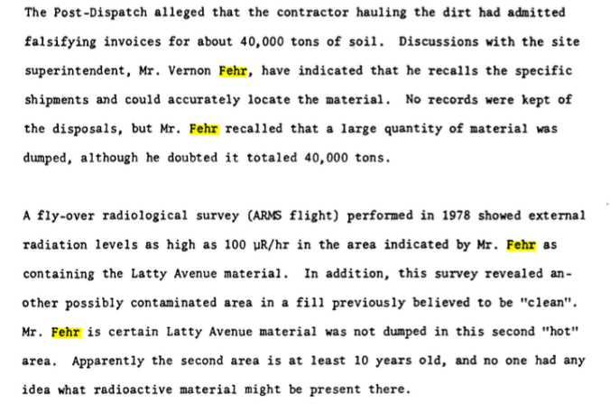
No doubt exists that B&K Construction Co. hauled more than 40,000 tons of radioactive material from Cotter Corp.’s Latty Avenue storage site in Hazelwood, Mo. and illegally dumped it at the West Lake Landfill in Bridgeton, Mo. between July and October of 1973.
But a 1981 government report obtained by the Environmental Archives now suggests some of the nuclear weapons waste at the landfill was quietly disposed of years earlier. Forty-five years later it remains a mystery where the latter nuke waste originated or who dumped it
The report, released under the Freedom of Information Act, is based on a 1980 site investigation by the Radiation Management Corp., a Nuclear Regulatory Commission contractor. The report states that the then-landfill superintendent recalled with certainty that the Latty Avenue waste was disposed on approximately two acres in the southern portion of the landfill.
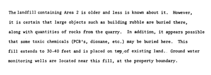
Vernon Fehr, the superintendent who had first-hand knowledge of the landfill operations for the time periods in question, also said with certainty that none of the radioactive materials from Latty Avenue were dumped in the other contaminated part of the landfill, which is comprised of approximately 8 acres in the northeast section.
The NRC report states, “the second area is at least 10 years old (in 1981), and no one had any idea what radioactive material might be present there.” If that timeline is correct, it means large volumes of radioactive waste were secretly dumped at the landfill at least two years prior to B&K arriving on the scene.
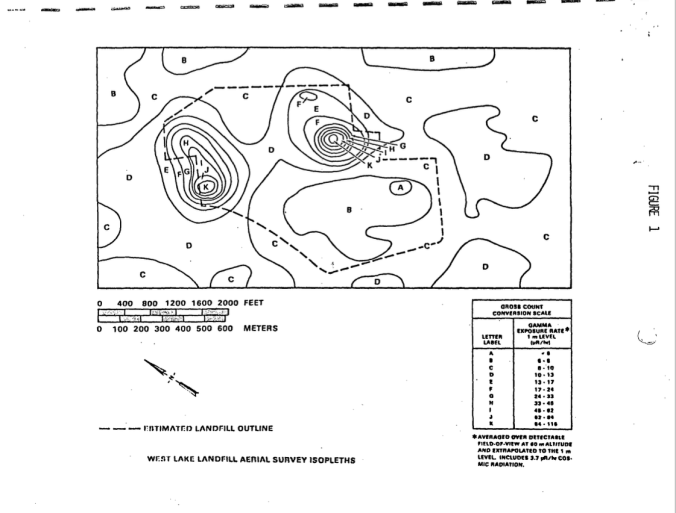
Radiation Management based its findings on both the landfill manager’s testimony and a 1978 aerial survey of the landfill by EG&G engineering firm. The aerial survey discovered radioactive contamination above background on 2.6 acres acres in the southern part of the landfill and also present on 8 acres in the northeast portion of the site.
Current attention has been directed mainly at area of the landfill nearest the underground fire, which is burning at the adjacent Bridgeton Landfill.
The eight acres in the northeast sector of the site include a toxic stew of chemical waste in addition to the radioactive materials. The mixed contaminants are known to be migrating off site and leaking into the aquifer. The landfill is in the flood plain, approximately 1.5 miles away from the Missouri River.
The exact nature of the all radioactively-contaminated materials and their precise locations remains uncertain because the EPA has failed to fully characterize the site since taking over the clean up in 1990. In short, despite untold numbers of various tests and surveys over the years, a comprehensive grid test of the entire 200-acre Superfund site has never been conducted.